


Parts of Northumberland are experiencing “severe flooding” amid “extreme conditions”, an MP has warned.
Blyth and Ashington MP lan Lavery said on Tuesday evening that his office had “taken numerous calls about the serious flooding” in south-east Northumberland.
A local councillor said roads had been closed near Blyth and fire and rescue service crews were at the scene.
It came after the Met Office warned that thunderstorms may cause flooding and road closures across parts of southern England.
A yellow weather warning for thunderstorms was issued by the Met Office from 10am on Tuesday until 3am on Wednesday.
An area from Dorset to Kent, and stretching as far north as Worcester and across to East Anglia, is covered by the warning.
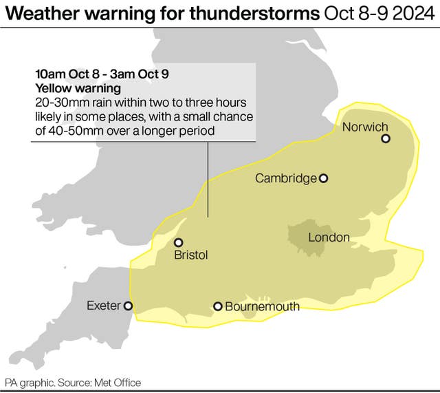
The Met Office said spray and sudden flooding could lead to difficult driving conditions and some road closures.
It added that there was a small chance some communities could be cut off by flooded roads.
Mr Lavery said on Tuesday evening that south-east Northumberland was “experiencing severe flooding”.
In a statement posted on social media, the Labour MP said: “We are aware that the emergency services and NCC (Northumberland County Council) are on the ground doing their best in the extreme conditions.
“I know many people have seen their properties flooded and this is just the latest in a series of recent floods affecting the area and there are a number of issues which has made them worse.”
In a post on social media, county councillor Scott Dickinson said: “A number of roads have been closed in the Blyth area and NCC teams are at the scene, along with crews from Northumberland Fire and Rescue Service, Northern Powergrid and Northumbria Water.”
There were more than 70 alerts warning of possible flooding on Tuesday evening, including in Bristol, where residents earlier reported traffic delays from excess water on the roads.
Flood warnings, meaning flooding is expected, were also in place in four locations on Tuesday evening.
These were at Gog Brook in Warwick, Bunches Brook from Broadway to Childswickham in Worcestershire, and for low-lying properties near the River Brue and Glastonbury Millstream from Lovington to Highbridge in Somerset.
A warning was also issued for the B1040 Thorney to Whittlesey Road to the south of the River Nene near Peterborough.
The Whittlesey Wash flood storage reservoir, east of Peterborough, is being operated to protect nearby communities from flooding.
National Highways said the M5 in Somerset was temporarily closed southbound on Tuesday afternoon due to flooding after heavy rainfall.
Liam Eslick said: “We are looking to see quite a lot of rainfall with 20mm-30mm in two to three hours but there could be some very heavy bursts with 40mm-50mm falling over a longer period of time.
“We are expecting to see not just rain, we are expecting some hail and quite a lot of thunder, a lot of these showers could turn thundery as they combine together and become larger systems.
“So we are expecting thundery outbreaks and quite gusty conditions, it’s a pretty hefty system across the south.”
The Met Office said showers and thunderstorms will move north and east across southern Britain into Tuesday evening, before gradually clearing from the west.
It added that 40mph gusts of wind are possible in the south of the warning area.


Comments: Our rules
We want our comments to be a lively and valuable part of our community - a place where readers can debate and engage with the most important local issues. The ability to comment on our stories is a privilege, not a right, however, and that privilege may be withdrawn if it is abused or misused.
Please report any comments that break our rules.
Read the rules here